Indigenous Heritage and Early Exploration
The Bly area lies in the Upper Sprague River Valley, a region inhabited for millennia by Native peoples. The Klamath Tribes – a confederation of Klamath, Modoc, and Yahooskin Paiute – traditionally lived throughout the Klamath Basin, including the uplands of the Sprague River Valley. In their language, the Sprague River was called Plaikni Koke (“upper river”), often shortened to Plai, indicating a stream coming from the high country. This reflects the valley’s geography, as the Sprague’s two forks rise on the slopes of Gearhart Mountain northeast of present-day Bly. For countless generations, Native people hunted, fished, and gathered in this rich watershed; even today the Klamath celebrate the spring Return of c’waam (sucker fish) in the Sprague River, an ancient tradition tied to the Creator’s provision.
Language and place
The “upper country” idea shows up again and again in Bly’s history: higher-elevation meadows and creeks feeding the Sprague, seasonal movement, and later—roads, rail, timber harvest, and recreation radiating out into the forested uplands.
The area near Yainax Butte (just west of present-day Bly) was a major intertribal meeting ground. Oral histories describe gatherings at Yainax to trade, feast, gamble, and recount war exploits under the shadow of “The Mountain,” as Yainax means in the Klamath language. From the early 19th century, European-American explorers and fur traders entered Klamath lands. In fall 1826, Hudson’s Bay Company trappers under Finan McDonald and Thomas McKay reached as far south as the confluence of the Sprague and Williamson rivers near present-day Chiloquin. That December, famed HBC trapper Peter Skene Ogden likewise came into the Klamath Basin and likely sent men up the Sprague River in search of beaver. U.S. Army expeditions also passed nearby: in 1843 John C. Frémont skirted the region via Klamath Marsh and Summer Lake, and in 1846 Frémont (guided by Kit Carson) circled Upper Klamath Lake and skirmished with Klamath warriors along the Williamson River. These early incursions set the stage for later U.S. influence, but through the mid-1800s the Sprague River country remained predominantly under Native control.
The 1864 Treaty of Klamath Lake created the Klamath Reservation and relinquished Native claims to vast areas of south-central Oregon. However, the treaty’s boundary description was ambiguous, and a U.S. survey in 1870 excluded the Upper Sprague River Valley, leaving the Bly area outside the reservation. Klamath leaders maintained the valley should have been included. A federal commission in 1890 agreed the valley had been wrongly excluded and recommended compensation, but Congress never delivered the payment. The disputed land was opened to non-Native settlement, reshaping the valley’s future.
The very name “Bly” reflects this Indigenous heritage. “Bly” comes from the Klamath word p’lai, meaning “up” or “high,” a reference to the town’s location on the upper Sprague River. Early ethnographers noted that plai (or p’lai) was used by the Klamath to denote the upper Sprague River country and its people (Plaikni, “people living high up”). One interpretation held that “Bly” or “Blydell” meant “heaven” in Klamath, reflecting the high elevation; P’laikni even took on the meaning “heavenly” or “the Christian God” after missionaries arrived. According to pioneer accounts, Elizabeth Lofton — Bly’s first postmistress — proposed the name around 1883, replacing the original name “Sprague River” for the settlement.
Settlement and Community Formation in the 19th Century
Permanent non-Indigenous settlement in what became Bly began in the early 1870s. The region was remote and initially part of Jackson County, then Lake County, before Klamath County’s creation in 1882. The Gearhart brothers — James Polk Gearhart and William H. Gearhart — were among the earliest pioneers in the Upper Sprague Valley, driving cattle into the area around 1872–73. In 1873, James Gearhart petitioned for a U.S. post office in his cabin, calling the location “Sprague River” and noting there was “no village yet.” The Sprague River Post Office was approved in 1873, marking the formal founding of a community. The post office moved often in those early years, following the postmaster’s home, and in 1883 it was officially renamed Bly with Elizabeth Lofton as postmistress. Many early homesteaders arrived cautiously, especially after the Modoc War of 1872–73; some families briefly fled during that conflict and returned once it was over. Bly itself was not surveyed and platted as a town site until 1928, so in the 19th century it existed more as a scattered ranching community than an incorporated town.
Several settler families and figures left an imprint on Bly’s early history. The Gearhart brothers — James P. and William H. — were early cattlemen and hosted the first post office. Jacob “Fritz” Munz established a cattle ranch on what became the Bloomingcamp (BK) Ranch. Edward, George, and Henry Bloomingcamp purchased the BK Ranch in the late 1880s and expanded it significantly; Henry died in an accident while blasting stumps for an irrigation ditch. W.F. “Billy” Reed arrived by the 1890s, running the Pioneer Hotel, a livery and feed stable, and later serving as postmaster. Brothers J.O. and J.S. Watts opened one of Bly’s first general stores. The Owen family were early settlers and merchants tied by marriage to the Watts family. The Obenchain family established ranches nearby and preserved local stories and letters about frontier life. The Garrett family were early ranching settlers whose stories appear in local memory.
By the 1890s, Bly had grown into a modest ranching village. The U.S. Census of 1890 recorded 119 residents in the Sprague River precinct (Bly’s voting district), rising to 145 by 1900. A 1905 regional gazetteer noted Bly consisted of “one store and a hotel combined” as of 1888, but by 1905 it had two general stores, two hotels, and a saloon serving the surrounding ranching country. About 150 votes were cast in the 1904 election in the Bly precinct, indicating roughly 750 people in the wider area. The valley’s economy was almost entirely agricultural.
Early Economy: Ranching, Farming, and Frontier Life
Well into the early 20th century, ranching remained the backbone of Bly’s economy. The broad valley provided excellent summer pasture, and irrigation from the Sprague and Fish Hole Creek supported hay fields. Seasonal cycles of cattle and sheep grazing defined life for many residents. Bly sits at about 4,360 feet elevation in a transitional zone between forest and high desert.
Early community life retained a rough frontier character. Saloons and roadhouses were lively, and old stories tell of cowboys riding horses into bars, blacklists for local drunks, and lively social centers alongside stores, schools, and churches in a remote, unincorporated town with limited formal institutions.
Despite this, Bly organized key institutions early. An informal log-cabin school existed by 1873. By 1910, a new school was built. That school burned in 1932, but residents rebuilt it the same year, and the 1928-built gym survived and remains in use today.
Church life took root as well. By the 1930s–40s, Bly had an active Christian and Missionary Alliance congregation, and its white chapel—later known as Standing Stone Church—became a community landmark. Civic amenities expanded after World War I, including a community hall and movie theater. In 1948, the Arch Memorial Theater opened to a standing-room-only crowd.
Timber Boom and the Coming of the Railroad
In the 1920s, Bly’s trajectory changed dramatically with the rise of the timber industry. The valley is surrounded by vast pine forests — part of the Fremont National Forest (established 1908) — and for decades that timber was largely untapped. The pivotal moment came with the expansion of the Oregon, California and Eastern Railway (OC&E), envisioned by promoter Robert E. Strahorn to connect Klamath Falls with the interior. The line reached the village of Sprague River by 1923 and was extended east to Bly in 1928. Anticipating the railroad, realtors J.C., May, and T.M. Edsall platted an official townsite for Bly in June 1928, laying out streets and lots for the first time. The rails finally reached Bly on November 24, 1928, and the community quickly gained a depot and a reliable rail link to Klamath Falls.
With rail access, timber became king. Logging camps sprang up almost overnight. The Pelican Bay Lumber Company established a huge camp south of Bly near Robinson Springs, employing around 200 men.
The Ewauna Box Company operated another camp near Quartz Mountain. Logs cut at these camps were flumed or trucked to the new railhead at Bly for shipment out.
In 1931, H.R. Crane built Bly’s first major sawmill just north of town, an electrically driven bandsaw mill capable of 30,000–40,000 board-feet per day. By mid-1931 some 12 new houses had been built or moved into town for mill workers and their families. The mill pond was excavated, spur roads were pushed into the timber, and Crane’s “portable” mill was up and running by June 1931, wowing observers with its modern design. Bly’s timber economy peaked in the 1930s, with trains hauling thousands of carloads of logs each year.
The boom reshaped the town quickly. In December 1928, the Klamath Evening Herald reported Bly suddenly had “2 stores, 2 hotels, a warehouse, [and a] Shell Oil Company distributing plant,” and that it was “just the beginning” of growth. The Klamath News wrote in July 1929 that Bly had “jumped from a place of a few houses into quite a prominent town of 300 people,” crediting the railroad, the completion of the highway (today’s Oregon Route 140), nearby logging camps, and the rich stock country. Bly now boasted sawmills, lumber yards, new stores and cafes, and an influx of loggers alongside the old ranching families.
Another mill and company town, Ivory Pine (“Podunk”), sprang up about 10 miles northwest of Bly near the North Fork Sprague River. It operated into the late 1940s and drew workers and their families; kids were bused to Bly’s school. The camp gained a reputation for its rowdy off-shift scene and a dance hall for loggers. The Bly Ranger Station was established during this boom. In 1936 the Forest Service built its new office (Building #2000), and CCC crews added additional buildings between 1936 and 1942. The Civilian Conservation Corps also operated Camp Bly (established 1938), helping with forest road building and fire management. The ranger station complex remains a centerpiece of Bly and is listed on the National Register of Historic Places.
World War II Tragedy: The Balloon Bomb Incident
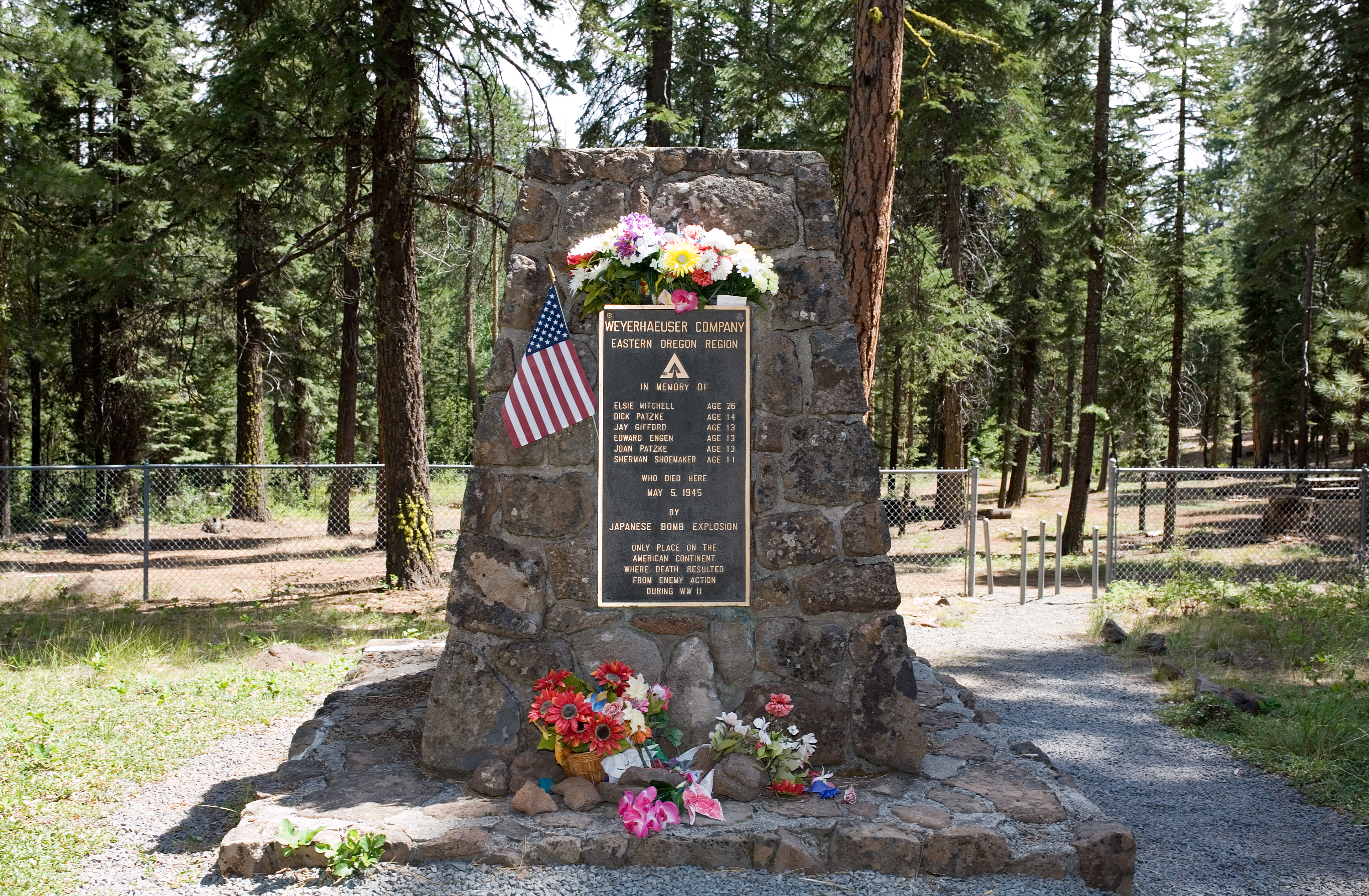
Despite its remote location, Bly gained unwelcome national attention during World War II as the site of the only enemy-caused fatalities in the continental United States. In late 1944, Japan launched Fu-Go balloon bombs — some 9,300 hydrogen balloons carrying antipersonnel and incendiary devices — designed to ride the jet stream across the Pacific. On May 5, 1945, a Sunday school picnic from Bly’s Christian & Missionary Alliance Church ended in disaster when one of those bombs exploded about 13 miles northeast of Bly near Gearhart Mountain and Leonard Creek.
Reverend Archie Mitchell had driven with his pregnant wife Elsie (26) and five local children (ages 11–14) into the woods for a fishing and picnic outing. As Archie parked the car, Elsie and the children walked ahead and found a strange balloon-like object on the forest floor. Archie later recalled that he warned them not to touch it, but the device exploded moments later. The blast killed Elsie Mitchell and the five children: Dick Patzke (14), Joan Patzke (13), Jay Gifford (13), Edward Engen (13), and Sherman Shoemaker (11).
Elsie Mitchell was among those killed in the May 5, 1945 balloon bomb tragedy near Gearhart Mountain.
The device that caused the tragedy was part of the Fu-Go campaign. Only a few hundred of the balloons reached the U.S. and Canada, and they caused little damage; the Bly explosion was the only fatal incident. The tragedy was initially shrouded in secrecy: a May 7, 1945 report noted an “explosion of unannounced cause,” and details were censored to avoid alerting Japan that the balloons were effective. Later that month the government warned the public and lifted the news blackout.
A stone Mitchell Monument was erected at the blast site in 1950, with Oregon Governor Douglas McKay stating the victims were war casualties “just as surely as if they had been in uniform.” The monument’s plaque notes this is the only place on the American continent where death resulted from enemy action during World War II. Over time, acts of reconciliation followed: Japanese citizens sent paper cranes and letters of apology, visitors traveled to Bly to offer personal apologies, and cherry trees were planted as symbols of peace and friendship. The site is now a Forest Service recreation area and National Register landmark, and the Fu-Go balloons are considered the first intercontinental weapons in history.
Mitchell Monument
The memorial and recreation area preserve this history and mark the only confirmed civilian fatalities from enemy action on the U.S. mainland during World War II.
Postwar Developments and Economic Change
After World War II, Bly’s timber-driven boom began to ebb. H.R. Crane sold his mill in 1946 to a new partnership (Spangler Lumber Company) and moved to California. The North Fork mill was later operated by the Ivory Pine Company until the local timber played out in the late 1940s. The Klamath Tribes’ reservation was terminated in 1954, and large portions of former reservation forest were transferred to the U.S. government. In the early 1960s, about half a million acres were purchased and reconstituted as the Winema National Forest, later merged with Fremont National Forest in 2002. Bly remained the district headquarters for the combined forest’s Bly Ranger District, but management priorities gradually shifted toward multiple-use and habitat conservation.
On the industrial front, Bly’s sawmills saw consolidation and closure. Weyerhaeuser purchased the main mill in 1970, modernized operations, and extended logging rail spurs as the OC&E became primarily a logging line. By the early 1980s, accessible timber was largely harvested and the Bly mill closed in 1984, ending an era. The last log train left Bly in 1990, and the OC&E railroad corridor was railbanked and donated to the State of Oregon. The old trackbed is now the OC&E Woods Line State Trail. The 100-mile trail is built on the old railbed of the Oregon, California and Eastern Railroad (OC&E). Open all seasons to non-motorized recreation, the trail begins in the heart of Klamath Falls and extends east to Bly and north to the lush Sycan Marsh — Oregon’s longest state park trail and a living reminder of the logging railroad that once sustained Bly.
These changes reshaped the community. Bly’s population peaked around the mid-20th century and then steadily declined. By 2000 the greater Bly area’s population was under 500, and the 2020 U.S. Census recorded 207 residents in Bly. Ranching continues on a modest scale, with seasonal Forest Service and recreation work providing additional employment. The community still supports a K–6 elementary school, post office, general store, and a few businesses serving travelers on Highway 140. The Bly Ranger Station Historic District, with its 1930s buildings, remains preserved on the National Register of Historic Places.
Community and Culture in the 21st Century
Bly is a quiet, close-knit community that takes pride in its history and natural setting. As an unincorporated town, it has no formal city government or council; local issues are often addressed by volunteer community groups. Annual events, holiday bazaars, and volunteer fire and church groups form the social backbone. The Arch Memorial Theater remains a touchstone of community memory, and annual gatherings at the cemetery and Mitchell Monument keep the past present.
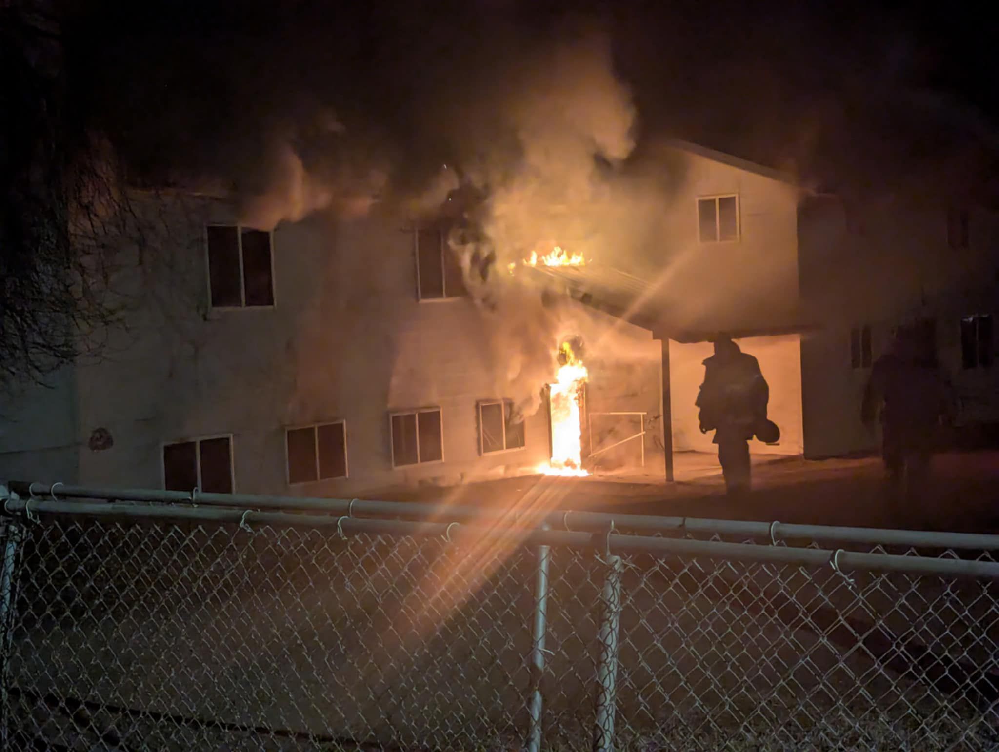
The historic Standing Stone Church (formerly the Christian & Missionary Alliance chapel) suffered a major fire in early 2025 (Wednesday, Jan. 29). The building was a complete loss and the community is currently rebuilding it with support from locals and volunteers. The Bly CMA Church still holds services and remains a symbol of resilience and forgiveness for a community shaped by the 1945 tragedy.
Standing Stone Church rebuilding
The 2025 fire destroyed the historic building. Rebuilding efforts continue with local and volunteer support. Read the archive.
Bly continues to face modern challenges of rural life, including limited jobs and long distances to services, yet its residents remain resilient. The town’s story is kept alive by local historical societies and publications like Klamath Echoes, which dedicate issues to Sprague River and Bly history. Every May the names on the Mitchell Monument remind Oregonians of a singular event that tied their remote community to world history. The community’s identity is rooted in ranching, timber history, and a deep connection to the surrounding land.
Klamath Echoes: Sprague River–Bly
Read Volume 12 online or download the PDF, and explore the full Klamath Echoes series for more regional history. Open the issue.
Key dates at a glance
- Pre-contact: Upper Sprague River corridor is an Indigenous homeland; Yainax Butte is a major gathering site.
- 1826: Hudson’s Bay Company trappers reach the Sprague and Williamson rivers.
- 1864: Treaty of Klamath Lake establishes the reservation west of Bly.
- 1870: U.S. survey excludes the Upper Sprague Valley from the reservation.
- 1872–1873: Modoc War; some early settlers temporarily flee and later return.
- 1873: Sprague River post office established in the Gearhart cabin.
- 1883: Post office renamed “Bly.”
- 1910: New schoolhouse built; the 1928 gym later survives the 1932 fire.
- June 1928: Edsall family plats the Bly townsite.
- Nov 24, 1928: OC&E railroad reaches Bly; rapid growth follows.
- 1931: H.R. Crane opens Bly’s first major sawmill.
- 1936–1942: Bly Ranger Station built; CCC Camp Bly established in 1938.
- May 5, 1945: Fu-Go balloon bomb kills six civilians near Gearhart Mountain.
- 1950: Mitchell Monument dedicated at the blast site.
- 1970: Weyerhaeuser acquires the Bly mill.
- 1984: Bly mill closes, ending the major timber era.
- 1990: Last log train leaves; OC&E line is railbanked.
- 2002: Fremont and Winema National Forests merge.
- 2003: Mitchell Monument listed on the National Register of Historic Places.
- 2021: Bootleg Fire impacts southern Oregon forests.
- 2025: Standing Stone Church fire; rebuilding underway.
Featured Articles
Sources
- Klamath County Historical Society, Klamath Echoes No. 12: Sprague River–Bly (1974) and other Klamath Echoes issues. klamathcountyhistoricalsociety.org
- The Klamath Tribes, “Our History.” klamathtribes.org/history/
- Treaty of Klamath Lake (1864): National Archives. catalog.archives.gov/id/299820
- Oklahoma State University, Indian Affairs: Laws & Treaties (Kappler). digital.library.okstate.edu
- BLM General Land Office Records (Klamath Reservation Survey, 1870, S.J. Mercer). glorecords.blm.gov
- U.S. Congressional Serial Set (Klamath Indian Commission, 1890). loc.gov/collections/u-s-congressional-serial-set/
- Lewis A. McArthur, Oregon Geographic Names (7th ed.). ohs.org
- F.A. Shaver et al., An Illustrated History of Central Oregon (1905). archive.org
- U.S. Census Bureau (historic summaries; 2020 Bly CDP). census.gov/history and data.census.gov
- OC&E Railroad overview. en.wikipedia.org
- OC&E Woods Line State Trail (Oregon State Parks). stateparks.oregon.gov
- Historic newspapers: Klamath Evening Herald and Klamath News. oregonnews.uoregon.edu and news.google.com/newspapers
- USDA Forest Service, Fremont–Winema National Forest. fs.usda.gov/fremont-winema
- NRHP: Bly Ranger Station Historic District. npgallery.nps.gov
- Oregon Encyclopedia, Lee Juillerat, “Balloon Bombs.” oregonencyclopedia.org
- Herald and News (Klamath Falls), “Japanese balloon bomb killed six 60 years ago today” (May 5, 2005). heraldandnews.com
- Warfare History Network, Steve Dykes, “Project Fu-Go.” warfarehistorynetwork.com
- USDA Forest Service, Mitchell Monument Recreation Area. fs.usda.gov
- NRHP: Mitchell Monument. npgallery.nps.gov
- Oregon History Project, Stephen Most, “A Forest Named Winema.” oregonhistoryproject.org
- Weyerhaeuser Company history. weyerhaeuser.com
- Bootleg Fire (ArcGIS StoryMap). storymaps.arcgis.com